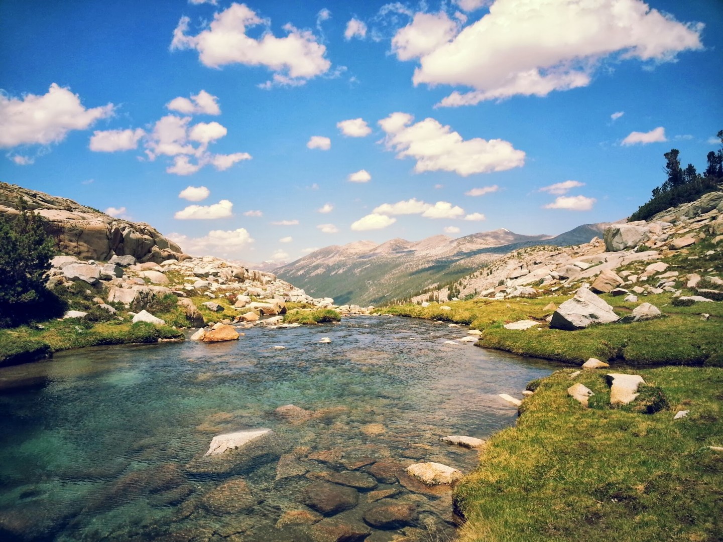
Lyell Canyon is one of the most popular backpacking and day hiking trail in Tuolumne Meadows, Yosemite National Park. The is also a section of the John Muir Trail (JMT) and Pacific Crest Trail. To prevent any confusion, the JMT runs from Yosemite Valley through Tuolumne Meadows along the Lyell Canyon down to Mt. Whitney. So by doing this trail, you will be doing a portion of the JMT.
This is one of the most beautiful places I’ve ever seen to my entire life. The long stretch of canyon and the towering mountains along both sizes of the canyon, the stunning expansive view from the top of the pass, and countless numbers of lakes and streams. This is simply a must do for any backpackers.

overview
Trail: Tuolumne Meadows to Island Pass via the John Muir Trail
Where: Yosemite National Park and Ansel Adams Wilderness in Inyo National Forest
When: These pictures were taken in July, 2013. Snow condition varies year to year. This was a very low snow year.
Distance: 34 miles round trip, 3,000 ft in elevation gain total
Days: 2 days, 1 night
Conditions: trail is extremely easy to follow. Popular trail but plenty of solitude.
Water: plenty of lakes and streams
Highlights: Lakes, great views, meadows, and waterfalls
Permit: Required from the permit station. Walk-In permits available on first come, first served basis
Camping before & after: If you want to camp before & after because of the long drive home or to acclimate, there’s a backpacker campground in the Tuolumne Meadows. You will be given permission to camp there once you pick up your permit. It is guarantee that you will get a site. There may not be any site left but there’s not really a limit to how many people can stay in each site, so make friends if spots are full. I slept in other people’s campsites when i was there as well.
Parking: You will park at a lake overnight camping area. You will be given more instructions when you pick up your permit.

experience
You will start from the Tuolumne Meadows campground and get on the John Muir Trail. Then you will take a long 6-7 miles walk along the Lyell Creek. This part of the trail is almost completely flat, so enjoy it while it lasts. Although it’s flat, it’s not less scenic than the passes, so take your time and really absorb in the view of the canyon. This area in particular has a lot of bear activities, so make sure that you carry bear canister to store your food.

Once you get to the base of the Donahue Pass, you will immediately notice the significant elevation gain for the next few miles to the top of the pass. Well, it’s been flat the whole time, so now you will work your butt off to get over this pass. Don’t worry, just take your time and you’ll get there. The key here is to give yourself enough time to get through everything at your own pace.


If you feel like you won’t be able to get to Island Pass because it’s almost the end of the day or whatnot, i suggest that you get over Donahue pass and camp on the Ansel Adam Wilderness site. So basically, get over the pass and hike maybe a mile or two down. There are a lot of running creeks and there are spots to find campsites in this area. Camping on top of the pass can be very windy, exposed, and in case of thunderstorm, not a good idea.

Once you get to the top of the Donahue Pass, take a short break! There are some high country small lakes on top of the pass. The view is absolutely stunning. On the other side of the pass, you will enter Inyo National Forest. The view expansive! Check out video below.


Once you’re ready to keep going, just make your way down the pass and follow the trail. It will be a lot of down hill from now until you get to the base of Island Pass. Don’t worry, Island Pass climb isn’t nearly as intense as climbing over Donahue Pass.


A lot of people will take a few days to do this trail, and they would get all the day to the famous Thousand Island Lake. If you seek alone time or don’t want to be surrounded by other campers, i’d suggest that you camp on top of the Island Pass. It’s more flat and less exposed than Donahue Pass with a couple of large lakes. It’s beautiful and when i was there, i didn’t see anyone else. Earlier in the summer, there will also be less mosquitoes on passes as well due to wind and colder weather.


This concludes my journey! i headed back to Tuolumne Meadows the next day on the same way that I came in. I’ve never done this but you can make it into a loop by exiting at Mono Pass. More detail should be available on the yosemite website.
Have fun and stay safe!

Holy cow, these photos are amazing!! Adding this to my bucket list right now! Thank you!
Thank you for the comment! Yes, this is a part of the John Muir Trail and it certainly a must do for everyone! let me know if you have any questions when you plan on going out here!
It’s my dream to do the John Muir Trail! When do you think is the best time to go up there? I’m guessing the best time to go up there is during the early or late summer months because it is probably too cold from October – April and too hot in July/August.
Also, I am curious to know what kind of training (if any) you have/do for traveling on remote trails such as this. I’ve done several short trails in remote locations and really want to take on something long (like this and some of the other hikes you wrote about near LA) but I am afraid that I either don’t have the endurance or that I wouldn’t how to deal with emergencies or encounters with wildlife. I read and follow a bunch of blogs that review hikes all over, but training seems to be the one thing that no one talks about so I’d be really curious to hear your take.
Thanks for your reply! I’d say that late summer is better because early summer you run into a chance of snow. Especially in a big snow year, the trail could be largely covered in snow until late july in high elevation places. I wouldn’t worry about hot temperature too much because the JMT is consistently pretty high elevation so you won’t be too hot.
For training, i’ve never actually trained at all for any of this even Mt. Whitney. I would never consider myself an athlete or a very physical person but what i have, i guess, is hell of a determination to keep going.
I’d say that the best training to backpacking long distance is start carrying a lot of stuff on short trails that you usually take and see how you feel.
The usual weight that is comfortable for most backpackers to carry, depending on your physical abilities, is between 20% to 30% of your body weight. If you can go lighter, go lighter, and you will have a better time.
I’d start by carrying that much weight on a day hike and see how you feel about it. This is where you will really get a sense of how much you can really carry. Trying on a pack for a few minutes won’t. If you can generally hike about 8 miles in a day, i’d cut it down to 6-7 with a backpack on.
You can start small. Maybe begin with carrying a 10 pounds pack, then next weekend make it 15, and 20 while increasing the length of your hike.
I always tell people that hiking and backpacking has more to do with time. If you give yourself enough time to hike, there’s no need to rush, you can go slow and you will have a better time than having to rush trying to get from point A to point B before sunsets.
Planning ahead is important. It’s always nice to set a big goal for yourself but know your limit and plan a second camping site in case you can’t make it to your original campsite location.
For example, my friends and i went on a trip two weekends ago and we ran into a hail storm and thunder shower. We were going to hike 12 miles the first day but had to cancel before going over a pass can turn us into a piece of KFC. but i knew that there’s a great lake to camp half way, so we camped there.
But yea, i’m not sure if this is very helpful because i don’t really do any training at all. I just go on hikes and hopefully i’ll make it.
Let me know if you have any other questions!
Thanks so much for the long response! That is super helpful information. I didn’t know it would be snowy in July so that is really good to know.
I think you are right – determination is a huge factor. Even when I did a hike at Bryce Canyon I never noticed any of the steep climbs or got tired because I was way too distracted with the nature and beauty of the experience. That is great advice, though. I will try hiking with different weight packs and see how it is. It would be my dream to do the hike to Havasu Falls at the Grand Canyon or to do this hike that you blogged about!
You’re welcome! Snow really depends. This year was a very low snow year, so the trail and most of sierras have been snow free since May, but on a heavy rain year, snow can be around for pretty much the whole summer.
Havasu Falls is really my dream as well, and i’m thinking of doing it in Oct. or whenever reservation isn’t needed. Let me know if you have anymore questions.
Awesome, thank you for the advice!! I’m looking forward to your blog post about Havasu Falls someday 🙂
. It’s a Trojan Horse for those that wish to have our public trcekid into believing we have an adequate substitute for the Hetch Hetchy reservoir. We do not. There isn’t any. The gravity-fed system serves 7 percent of California’s population, city water officials say. Turbines from its dams generate hydroelectric power for city buildings, streetlights and traffic signals, the airport and the transit system. And two-thirds of the water from the system is sold to neighboring municipalities.All of this for just $30,000 a year. That was the rent set by Congress when it passed the Raker Act in 1913, giving San Francisco exclusive control and use of the Hetch Hetchy valley, despite opposition by 200 newspapers across the country and after a week of contentious debate.For the next decade stands of black oaks that had shaded deer and bear along the Tuolumne River through the half-mile-wide valley were removed along with 6 million board feet of lumber used to build the dam. By 1923, water began flooding what once were lush meadows.In recent years, politicians have argued that San Francisco is getting a bargain and that the rent should be increased. Others have said San Francisco is violating the Raker Act because the city’s transmission lines stop 30 miles short of the city and that Pacific Gas & Electric profits by carrying it the rest of the way.With opposition from then-Mayor Feinstein, Hodel brought the issue back to life in 1987 as a way of alleviating crowds and traffic in Yosemite Valley, which now sees 4 million visitors a year.Most recently the George W. Bush administration tried funding a feasibility study, but it was quashed politically by Democrats when Pelosi was Speaker of the House. San Francisco is known as a progressive city in many ways, especially environmentally. But in water, it’s just not the case. We’ve got a very sweet deal, said Spreck Rosekrans of Restore Hetch Hetchy, who has studied the issue for 20 years. Restoring the valley would undo the greatest wrong that has ever been done to a national park. Studies by the federal Bureau of Reclamation, the state Department of Water Resources and others show restoring the valley is technically feasible. The cost estimates range from $3 billion to $10 billion. On top of that staggering price tag, replacing the water supply is unrealistic when California already lacks infrastructure to provide enough water for its economy or environment, said Feinstein. We should move past this debate and focus on real solutions to California’s water challenges. The opposing sides also dispute the impact of reservoir removal. The Hetch Hetchy group says the city would lose 20 percent of its 1.7 billion kilowatt power-generating capacity, roughly the amount of excess production sold at cost to the Modesto and Turlock irrigation districts. The city says it would lose about twice that much, which would cost $41 million.In addition, utilities officials say water rates would increase by up to $2,777 per household a year and the city would be vulnerable during droughts.Mayor Lee and others argue that the timing is wrong to spend so much money on a project that ultimately could make Bay Area water deliveries less reliable.Proponents say passage of the measure in November would give San Francisco a chance to plan for restoration on its own terms. Voters would decide in four years whether to move forward with the plan. The opposition to removal is akin to the famous expressions many years ago about relinquishing the Panama Canal: `We stole it fair and square and we should keep it! Hodel said. Now that the shoe’s on the other foot, will the good people San Francisco accept for themselves the environmentalism they decree for the REST of us, or will it be Do as I say, not as I do hypocrisy that’s so familiar ?
Spectacular!
Thank you Pam!
Nice post. I was checking constantly this weblog
and I’m impressed! Extremely helpful info particularly
the final part 🙂 I maintain such info a lot. I was seeking this particular information
for a long time. Thank you and best of luck.
Do you have a spam issuee on this site; I alo am
a blogger, and I was wondering your situation; many of us have
developed some nice practices and we are looking to swap techniques with others, please shot me an email if interested.
I found simply the information and facts I already searched all over
the place and simply couldn’t encounter. What an ideal website.
Hi there everyone, it’s my first go to see at this web page, and paragraph is genuinely fruitful in support
of me, keep up posting these content.
It’s time for you to be alert and be vigilant to look and check for
1 or more signs of a cheating spouse:. Also buddy can
travel with you, while the headphones can be doubled over, buddy can
sleep in your bag-pack. Codependence is a particular relationship with one’s self in which the person doesn’t trust
his or her own experiences.
thank you for your blog I plan to do this hike July 7 2014 but go all the way to Agnew Meadows starting from Tuolumne Meadows so this helped.
Hi i just been to your site for the first time and i extremely loved
it, i bookmarked it and will return.
It’s a pity you don’t have a donate button! I’d most
certainly donate to this outstanding blog! I suppose for now i’ll settle for bookmarking and adding your RSS feed to my Google account.
I look forward to new updates and will share this website with my Facebook
group. Talk soon!
This looks amazing. I hope to do this hike in August when I visit California. What Camera do use? Does it differ depending on the trip?