While there are many canyons for hikers to explore in Capitol Reef National Park in Utah, one of the most popular and easiest accessed is probably Sulphur Creek. This hike is a river hike, and it is kind of like a mini version of the Subway Hike or the Narrows in Zion.

overview
Length: 5 miles (one way; this hike requires a shuttle or you can either hitchhike or hike back; 10 miles round-trip) Minimal elevation change but requires climbing.
Trailhead: You can start from either the visitor center (bottoms-up) or from Chimney Rock trailhead (top-down). The more popular option is top-down from Chimney Rock down to the visitor center. Click here to see complete Map illustration of Capitol Reef trails. You will see that Sulphur Creek is located on the opposite side of the Chimney Rock parking lot.
Getting There: From Capitol Reef visitor center, you will make a left back on Hwy 24 toward the town of Torrey. After about 4 miles, you will see the parking sign for Chimney Rock. Park there and then walk across the road to the opposite side. Look around for a little post that says “sulphur creek to visitor center 5 miles”. The post isn’t hard to find.
Skills: You can either do this as a top-down or bottom-up hike. Neither direction requires any special canyoneering skills or equipments. However, both requires the use of hands and some climbing and scrambling. Nothing is too hard on this trail. Every person in good health should be able to do this hike.
***top-down will require you to climb down three waterfalls while bottom-up will have you climb up the waterfalls instead. Everything else about the hike is the same, but rangers recommend you climb down because it’s easier and you will end at the visitor center instead of a remote location***
Best Time: Early summer or early falls when the temperature is warm. Although this hike is along the river, it is exposed to the sun most of the time which makes mid and late summer very HOT. Also, Thunderstorms and flashfloods are the most common during the months of July, August, and sometimes September.
Cautions: If there’s a chance of rain or thunderstorms at all or if it has been raining heavily in the area, DO NOT attempt this hike. Flashflood is a real danger in this part of the country and it takes lives every year. This hike may be amazing, but it doesn’t worth your life. Check in at the visitor center first before going down the creek.
Highlights: Beautiful canyon and vegetation, cool rock formations, three waterfalls, numerous water pour off, chill creek water, swimming in waterpools.
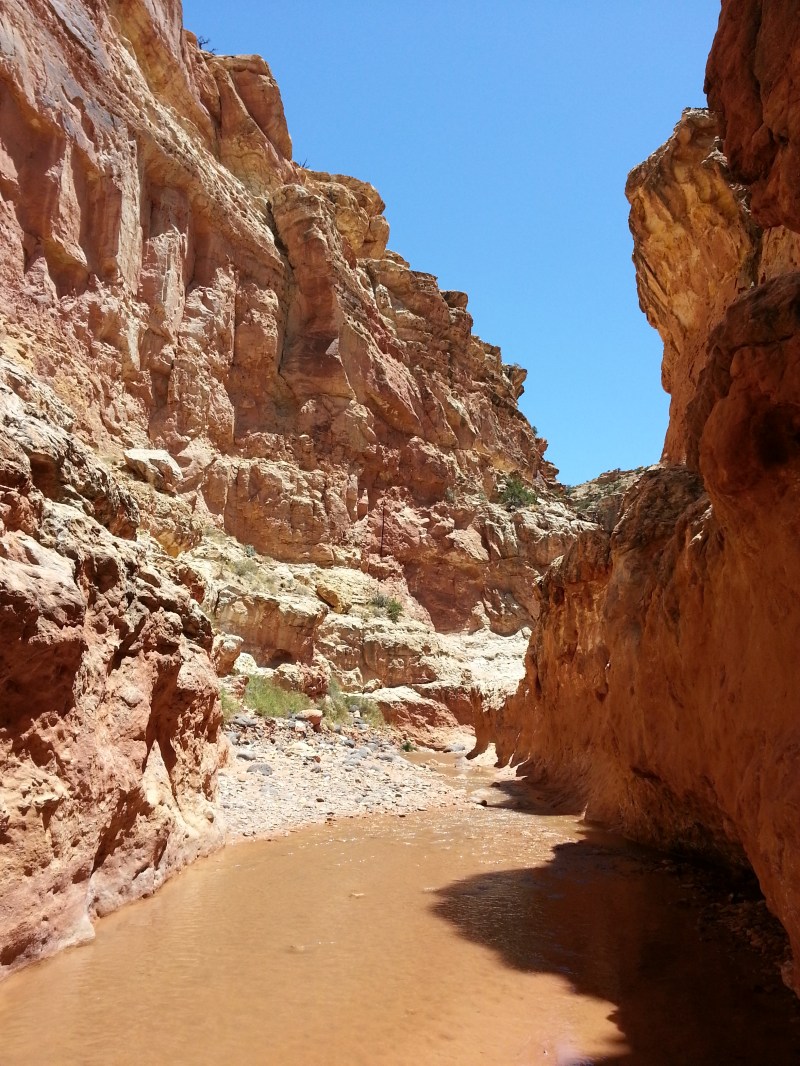
Trail condition: No real trail but there’s a hiker-made trail that is easy to follow. Once you get to the creek, the canyon walls will block both and you will just hike along the creek.
the hike
This hike is largely flat along the Sulphur Creek. However, it is still physically demanding as it requires you to cross the creek several times and climb up and down different ledges and waterfalls. This is a wet feet hike so don’t expect to stay dry.
You will park your car at the Chimney Rock trailhead, which is about 4 miles from the visitor center. Ask for a map from a ranger if you need directions. The visitor center also offers you a descriptive trail guide, so I highly recommend you going there and get this guide to help you find the trail and follow the route.
You will walk across the road and find a post that says “Sulphur Creek to visitor center 5 miles”. Once you find that, you will see a hiker-made trail. Follow that and it will drops you off on a small sandy wash. Follow the wash and it will take you to a bigger wash, turn left and keep follow the wash for about 1.5 mile.

Eventually, you will come to sulphur creek crossing. Turn left and follow the the creek downstream. You will hike for approximately 1 mile more before you encounter the first waterfall.

You will be standing on top of it and looking down into the waterpool below. THIS IS NOT A PLACE FOR CLIFF JUMPING. No matter how high the water is, the pool isn’t big enough for anybody to jump in.
To get down and continue, you will simply climb down a ledge on the right which drops down close enough to the ground for you to safely drop yourself down.

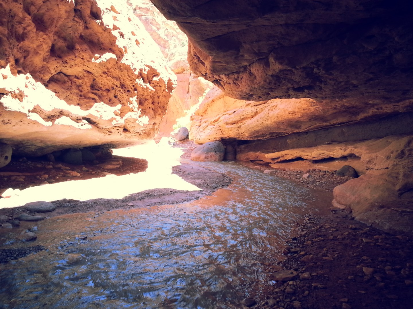
From waterfalls number 1, you will continue downstream and walk through short and narrow canyon in the above picture.
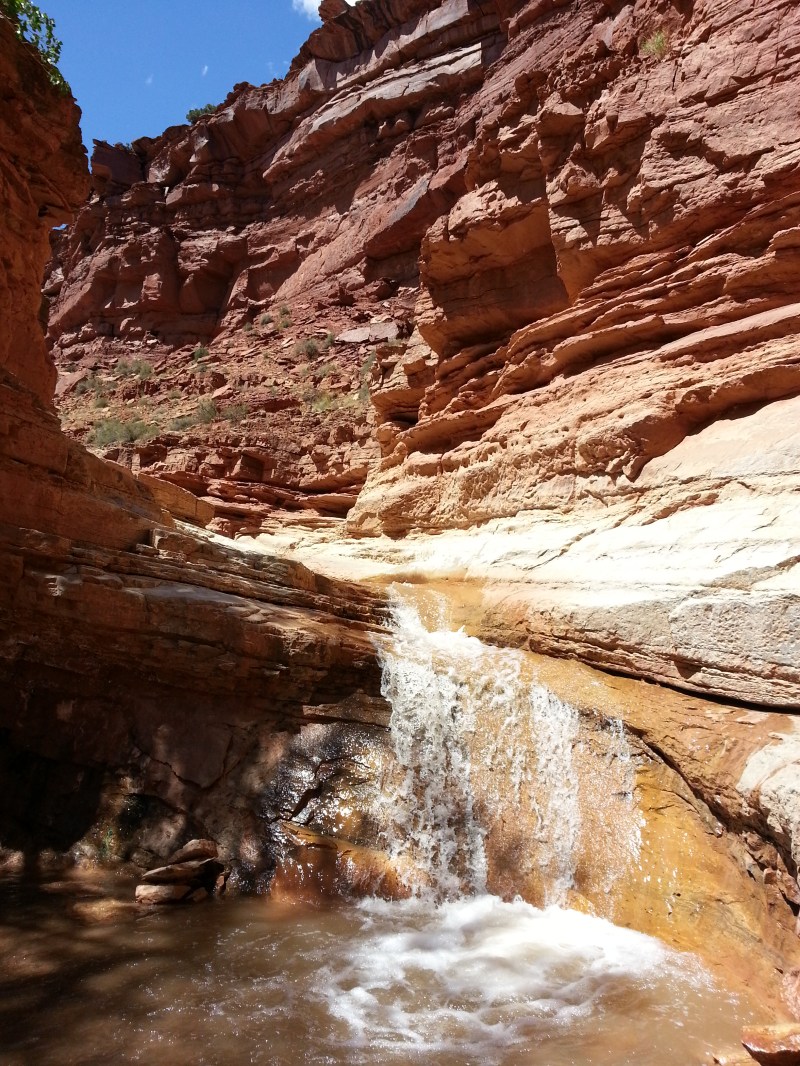
The second waterfalls is merely 750 feet away (or about 5 minutes of walking). To get down, you will again take the ledge on the right. This is a bit more difficult than the first one.

This is where I stopped and went for swimming. The water temperature was perfect. The air temperature was probably reaching 100F that day. This second waterfalls provide the perfect hanging out area with some shade unlike the first waterfalls, so if you want to have lunch, I recommend the second waterfalls as your break point.
From the second waterfalls to the last waterfalls, the creek becomes harder to avoid. It is much more safe to just hike in the river rather than trying to constantly jumping from rocks to rocks trying to keep your feet dry. Unnecessary jumping and boulder climbing lead to more chances of you breaking your ankle and getting injured.
The last waterfalls is where majority of the injuries happen on this hike, according to the rangers. There is not a dry ledge for you to easily climb down like the first two but rather a steep drop off into the waterpool. I came down by taking the ledge on the left which requires you to actually walking through the drop off the waterfalls itself. It may sound dangerous, but if you take your time and watch your footing, I think that it is completely doable. Another way that you can come down but is less ideal is to slide down the waterfalls. It is 8 feet fall and you will drop into the waterpool below. This is only possible is there’s a lot of water. if the creek is dry, then stick to what I did.
Once you come down waterfalls 3, you will simply keep following the creek downstream for maybe 0.3-0.5 miles back to the visitor center. You will eventually start hearing cars driving by on the freeway above. There will be a hiker-made trail on your left that leads you up on the side back to the visitor center.
staying safe
As this hike requires you to climb down ledges of the waterfalls, i highly recommend you wearing good shoes with excellent traction. Because you will most certainly get wet on this hike unless it’s really dry, you may feel like wearing flip flops or crocs on this hike, I highly DISCOURAGE from doing that. Wear a good hiking boots or great running shoes. You don’t want to slip and fall in this canyon. It will take miles and quite a few waterfalls for the rangers to come rescue you.
When crossing the creek, the safest way to do it is by walking into the creek. Yes, you will get super wet but it’s safe. Trying to jump from one side to the other or walking on wet and smooth rock is dangerous.
Also, check the forecast, let someone know that you’re doing this hike, and talk to the rangers before heading out there.
Other then that, this is one of the coolest hikes I’ve ever done, and I love it! I can’t wait to do it again when I’m back in Capitol Reef.


Beautiful area!
It surely is amazing!
nice to have a week off, and the sun is shining. Show was raemmd yesterday so I shall spend today playing with my new goodies….want to use the Frantage bits n bobs I broughthugs and best wishes
Cool hike, nice park, great pix . . . and one small but not unimportant thing you might consider fixing: It is Sulphur Creek, not Sulpher . . .
happy summer!
Hahaha rickwels, thanks for letting me know! Totally misspelled the place. I will fix it. It is quite important. Thanks 😀
Thank you so much, Jackie! It was truly close to perfect. I loved it so much I’m hsnoitg another one September 21-23. The weather will still be warm and fabulous! Yay!
Reblogged this on Just Go Places.